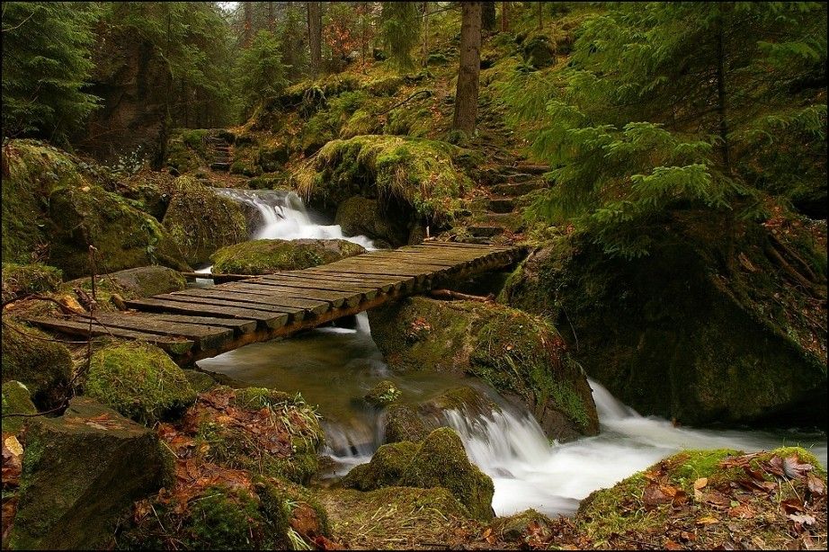


The starting point for this trip is the crossroad sign at Ústí Suché Kamenice, located near a small parking lot, directly on the bank of the Elbe River, 1 kilometre from Hřensko. You may also begin the trip directly in Hřensko, which is the most popular tourist centre in the Elbe River sandstone area. Starting at the above-mentioned crossroad sign we shall take the red sign towards "Suché Kamenice valley", about 2.5 km away, and towards the "Belvedér viewing tower, about 5 km away". We will began to climb along the rocky riverbed of Suchá Kamenice, which is usually dry during the summer. But if you are here during the spring or after heavy rains, then you can enjoy the beauty of many waterfalls that are created in the lower river section. On your way to the crossroad sign in the Suché Kamenice Valley you will get a chance to appreciate this very attractive part of our trip. We will climb uphill on a small path in a narrow canyon surrounded by mountain walls up to 50 meters high. Mosses and lichens thrive under the shadows cast by many rocks. These mosses grow around rocks, but also around fallen trees and stumps, making you sometimes feel like you are in the jungle. Then the red sign will take us above the canyon, where on sunny slopes you will find the picturesque little village of Labská Stráň, proudly showing many well-preserved folk houses. In the village pub we may refresh ourselves, but we will also find a crossroad sign here, which will tell us to take the red tourist route, and after 500 metres we will find the fascinating viewing post called Belvedér. This outdoor viewing terrace was built on a rock rising 130 m above the Elbe River, and was used for musical productions during the 18th century. You will find a nice restaurant and a guesthouse here. From the viewing terrace we will continue to follow the red sign, which will take us to the rock town located mainly in pine woods until we reach the crossroad sign "Pod Kamenským vrchem" (Under Rocky Hill) /5 km/. There are no significant changes in elevations so we will reach the crossroad sign easily using comfortable forest paths. Then we must walk 1 km to get to the Růžový hřeben (Pink Ridge) viewing terrace. Růžový hřeben (Pink Ridge) – consists of rocky walls with sandstone towers located on the right bank of the Elbe River. The viewing post offers beautiful aerial views of the Elbe River Valley and Sněžnická vrchovina (Sněžnická Heights), located on the opposite river bank. Besides the Elbe sandstones area you can see Buková hora (Beech Mountain) (with a transmitter) and other peaks of the neighbouring Czech Central Mountains. When we return from the viewing terrace back to the Růžový hřeben crossing sign, we will continue to follow the red sign for 2 km, until we reach the "Nad Loubím" crossroad. This passage is very interesting, because we will go down on a small path that winds near the edge of the rocks that line along the steep slope with dense vegetation growing on the bank of the Elbe River. Along our way you may visit several other rocky viewing posts, offering beautiful views of the Elbe River and the rocky ridge that together make up the Růžový hřeben formation. At the Nad Loubím crossroad sign we will begin to follow the green sign towards "Slunečná brána" (Sunny Gate) (2.5 km) and towards "Pod Kamenským vrchem" (Under Stone Hill) (4 km). We will have to climb back up the elevation that we walked down previously , but the countryside will change significantly. Rugged rocks with wild vegetation are now replaced with meadows and fields with small villages. We return to the world of rocks only after we pass the Slunečná brána (Sunny Gate) crossroad. On your right side above the crossroad sign you will see a small and hidden but very interesting rock town. The green road goes through this rock town. Once you get there you may admire its hidden charms. The impressive genuine rock gate offers limited views, but you may sit and relax here. Cesta k rozcestí (Road to the Crossroad) going towards Pod Kamenským vrchem continues through the valley and becomes more and more narrow until it turns into a rocky and narrow pass that will take us up to the crossroad sign. Then we have to descend 1 km through a field until we reach the village of Bynovec. While walking down you will enjoy unforgettable views of vast rocky monuments. It is difficult to imagine the real size of this sandstone area if you are inside the zone but if you are standing on an open peak many kilometres away, you may try to do so. From Bynovec we will take the road to Arnoltice. We cross the village square where we may see a former castle, then we pass by a soccer field and finally, we begin with a slight descent until we reach the village of Arnoltice. The history of this village dates back to 1352, when the first mention of the village was recorded. Today, we can find here a monumental late-Baroque church of the Assumption of the Virgin Mary and many timbered houses with ground floor and half-timbered second floor. In the centre we will find a crossroad post with a blue trail sign, which will take us to the foothills of the Arnoltické stěny (Arnoltické Walls) located in the section of the canyon that we still did not see. The Suchá Kamenice River fought its way through this canyon to join the Elbe River. A short distance behind the last village houses, the Kamenice River becomes a small brook, which slowly cuts its way deeper and deeper into the ravine. Then we go down to the bottom of the river and find ourselves in a mystical gloom created by thick forests and by the majestic cliffs above. Most of these cliffs remind us of multi-storey buildings. Enchanted by this unusual beauty we may now go down /2 km/, until we reach the Suchá Kamenice Valley, which we already explored and so for the last 2.5 kilometres we will be walking on the same road, which take us back to our starting point. Total length 24 km


