


The starting point of our journey is the wine-making village Velké Žernoseky located on a distinctive southern slope on the right bank of the Elbe River. We will find a late-Baroque chateau (purposefully used) here, the late Gothic fortified Church of St. Mikuláš (St. Nicholas) and folk empire brick houses. From the Velké Žernoseky – square crossroad we follow the green signs towards "Kalvárie" (Calvary) (2 km) We will go around the church down to the Elbe River (a ferry to Malé Žernoseky is here) and continue on a flat plain along the river while enjoying views of the rocks around Česká brána(Bohemian gate/Porta Bohemica). That is the name for the 4 km long and canyon-shaped area around the Elbe River flowing between steep slopes and rocky cliffs sometimes up to 140 m high. As soon as we turn right and leave the river, we begin to climb sharply and continue on a narrow path all the way to the most monumental peak of the Česká brána (Bohemian Gate). From the Calvary (259 m) crossroad, only about 100 metres separates us from the viewing post "Tři kříže" (Three crosses). The viewing post on the top of Calvary with three wooden crosses was already mentioned in records in 1587 in connection with many legends and tales. Here we will get a chance to see beautiful views of the Elbe Valley, Malé and Velké Žernoseky, Česká brána (Bohemian Gate), Lovoš and the western part of the Czech Central Mountains. We continue on a forest road still following the green signs through a slightly hilly terrain and after about 1 kilometre we pass by the Chapel of the Visitation of the Virgin Mary. In the last 500 m before Kamýk we walk along a road that presents us with an impressive view of castle ruins, located on the top of the rock in the middle of the village.
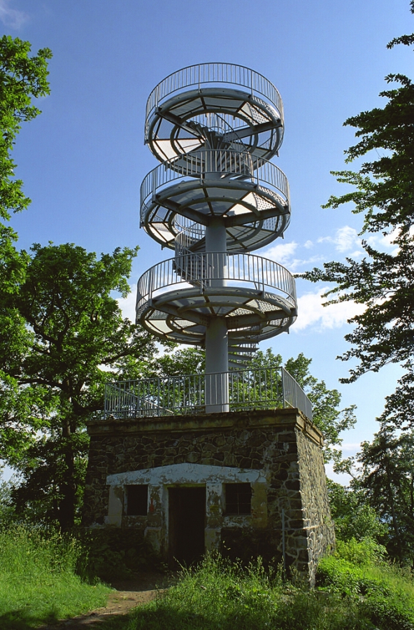
In this picturesque fruit-growing village we may take a look at the early Baroque chapel and several houses built in the traditional folk architectural style. Here we will join the blue signs and follow them uphill above the village and all the way towards the castle ruins. The castle ruins from the 14th century are freely accessible and open to the general public, and whoever finds the courage may climb up to the top of the square tower and enjoy the magnificent views in all directions. After our visit we take another climb through the forest following the blue signs and pass by the Plešivec crossroad. Behind the Chapel of St.John the Baptist we will undergo a steep climb to the peak of Plešivec, which is covered by a large sea of rocks. Towards the end of our climb we will get a chance to see Kamýk peak with its castle ruins and the adjacent Czech Central Mountains area. When on the top pay close attention to the blue signs (they go through the forest and not through the rubble), because several paths lead through the rubble and may confuse you. From Plešivec we must undergo a 4 kilometre long downhill walk to Sedlo pod Deblíkem – 289 m.In this rocky saddle we will start to follow the yellow tourist signs, all the way to "Krkavčí skála" (Raven rock) and "Varhošť– viewing tower". Now we go down and through the forest and meadows all the way to Tlučenské Valley, until we reach Krkavčí skála (Raven rock). We will walk for a while on a road in the valley passing by cottages. Make sure not to miss the right turn leading to the woods where we begin with a very steep climb. After we complete the steep climb we will get a chance to walk a little bit farther to the right (from the crossroad) and visit Krkavčí skála – viewing post (445 m). Here we may enjoy the magnificent views of Tlučenské Valley and the western part of the Czech Central Mountains. On our way back from Krkavčí skála we have to "deal with" one more short steep climb in order to get to the Pod Varhoštěm crossroad. From the crossroad we climb sharply uphill again until we reach the top of Varhošť (639), where we may also visit the freely accessible viewing tower. The 14 m high metal viewing tower built in 1972, offers (if the weather and visibility are good) charming views of the Czech Central Mountains. From Varhošt we travel down to the parking lot where we take a right turn towards the road going to Kundratice. On our way back we may notice the peak of Varhošť with its viewing tower. When we pass Kundratice we may also see the various rocky formations and surroundings of Holý vrch (Barren peak). A short distance behind the rocky cliffs we will encounter a green sign and begin following it all the way to the village of Hlinná. At the end of the village behind the crossroad we will take a right turn and follow the yellow sign towards "Plešivec – crossroad ". Finally, we are going to climb across a field road to reach the crossroad near a massive oak under Plešivec Hill. From Kamýk we take the same road we took during the first part of our trip to Plešivec. Behind the village we will leave the road and face three field roads in front of us. We will select the middle one, which will take us down and around fruit gardens all the way to the village of Malíč. The last 1.5 kilometres is a walk between fields back to our starting point in the village ofVelké Žernoseky. Total length 25 km.


