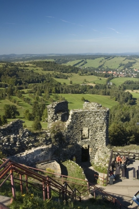
Our starting point is Jiřetín pod Jedlovou. Here, from the ČSAD bus stop called Náměstí (town square bus station) we will follow the green sign for 0.5 km, pass through the entire village and begin to climb uphill /3-4/ to Křížová hora (Cross Mountain). Jiřetín pod Jedlovou was established as a small mining town during the first half of the 16th century and became particularly famous for lead, copper, silver and tin mining and later also for textile and footwear production. Today, the town is mostly known as a tourist and recreational area and, since 1992, the town was declared a historical preservation zone dominated by its most valuable site, the Church of the Holy Trinity. Cross Mountain is dominated by the originally reconstructed wooden Chapel of the Crucifixion with a high tower, from where the mountain got its new name and became a popular tourist/pilgrimage site. We will take a steep climb towards the chapel and around the Way of the Cross consisting of 11 niche chapels with stone reliefs built in Rococo style. From the top you will have a nice view of Jiřetín. From Cross Mountain we continue to follow the green sign for 1 km, over a snow-covered meadow giving us nice views of the Tolštejn Castle ruins and the valley between Jedlová and Šibeniční vrch (Gallows Peak) towards sjezdovka (skiing slope). Here we make a left turn and follow the red sign towards Chřibská – ČSD (Railway station) (4 km). To cover the first half of this section we will take a downhill ride /3/. The second half has no significant elevations. Near Jedlová – village we will join the Jedlová Road (Pine Road). We must, however, leave this road after a short while and make a right turn after several metres in order to follow the red sign towards a forest path. Several metres before the railway stop Chřibská – ČSD we take a left turn to follow the yellow sign towards another railway stop Jedlová – ŽST (4.5 km). For the first 2 km of our journey to Malý Stožec we will be going slightly uphill /1-2/ - underneath Kozí hřbet (Goat's Back), but further on we will be mostly descending /1-2/ through forest and passing by the Tolštejnská Road, where we make a right turn, and after about 500 m we will reach the railway stop ŽST – Jedlová. Starting at the railway tracks, we will take a 1 km long climb /3/ and follow the green sign until we reach a turn which will take us to Jelení skála (Deer Rock). To get to Jelení kameny (Deer Stones) (consisting of two boulders - Konopáč and Deer Rock where you will also find a military bunker built during the era of the "First Republic") we must go through a densely forested slope /3-4/ and after about 500 m we get to the top of these rocks and will be able to enjoy a nice view of the surrounding countryside. Near the turn that took us to Deer Rock you may have noticed besides the military bunker also the Třípanský sloup (Three Estate Column), built in 1745, which used to mark the junction point where three estates met. Another 2 km of our green route will take us through a forest, which ends with a downhill slope /2/ that would take us to Nová Huť hunting cottage. From here we will take an uphill climb /2/ and follow the blue sign for 1.5 km around the forest and around the main road which goes to the town of Nový Bor. Near the parking lot below Stožecké Saddle (605 m), we will join the yellow sign and follow it for about 500 m along the main road, which we leave after a while and take a left turn towards the forest. After 2.5 km we will come back again to the Tolštejnská Road. From here we must take our last 1 km long uphill climb /2/ until we reach the turn that will take us to the castle. The extensive ruins of Tolštejn Castle date back to the 13th century. In 1866 a new castle restaurant was built here. The rocks on the top are accessible through a metal staircase with a bridge and offer excellent views of the countryside around you. To return from the castle ruins we will follow the red sign for 1 km all the way to Ranch, where we join the green sign. Passing around the stylish wooden ranch houses we will take a downhill ride /1-2/, then go over a skiing slope and over the Cross Mountain back to Jiřetín pod Jedlovou. Total length 22 km


