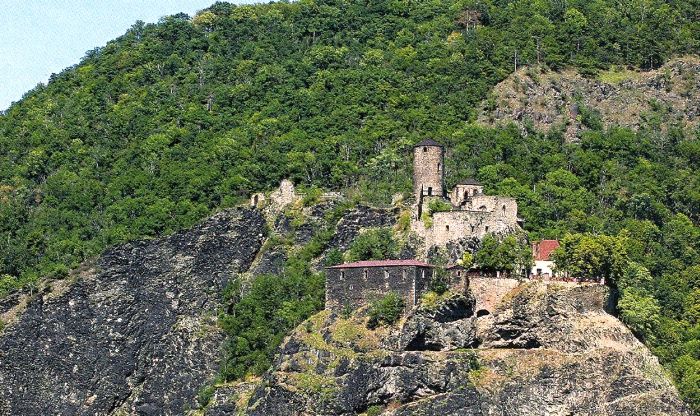


Our starting point is the tourist crossroad sign Střekov – castle located near ruins of a medieval castle built on a tall rock, on the right bank of the Elbe river, only short distance from the town of Ústí nad Labem. When inside this medieval castle, we may visit the castle restaurant and take a guided tour (or go alone without a tour guide) through a section of the palace, the tower with a viewing terrace or the Knights' Hall. From the castle we take the Educational Trail "Pod Vysokým Ostrým (Under the Big Sharp)" (hereinafter ET only) and follow the red sign towards "Nová Ves" (2 km). Along our way to Nová Ves (New Village) we will be going sharply uphill /2-3/ on a small path through a dense forest. After about 1 km, in a sharp left turn we may turn away from this road and continue straight ahead until we reach a beautiful viewing post offering views of the Elbe river and the Střekov castle.
From New Village we continue to follow the ET towards "Brná - bus" (7 km). When we are above the village we will be rewarded with a beautiful view of the town of Ústí nad Labem and the Czech Central Mountains. The Educational trail will turn to the right immediately behind the sign marking the end of the village, and we will follow the edge of the meadow through the Natural park Sluneční stráň (Sunny slope). We are passing around a hillside cleaned from trees and overlooking the winding Elbe river underneath the Vaňovský hill. From the Sunny slope we will be climbing up through forest and around a massive rock (the 10th stop of the ET - Rock walls - nesting place for owls and birds of pray) and fields, until we reach a turn that will take us to the Vysoký Ostrý peak. We take a left turn and begin with our last steep climb (for about 0.5 km) until we reach a rocky peak (587 m) with a wooden viewing post. The viewing post will surprise us with beautiful panoramic views of the Czech Central Mountains and the sharply cut Elbe canyon. From the viewing post we may enjoy panoramic views of the Czech Central Mountains and with the help of the bronze panorama we may figure out the names and heights of individual visible peaks. To return back from the turn we follow a short downhill road. But we also leave this road shortly and take another turn towards the woods. During our descent we will encounter the 5th stop of the ET - Decay of rocks and the creation of ruble dump under Malý Ostrý. Here, in the area that surrounds Výří skály (Owl rocks) you may see a large sea of stones - ruble hills so typical for Czech Central Mountains, whereas the tallest are right here in the Průčelská ravine. We continue with our steepening downhill walk until we reach the 4th ET station – Práce Labského údolí (Works of Elbe valley) located between the village Němčí and Vaňovský peak. Here we will learn that the stream of the Elbe river flowing through the Czech Central Mountians reaches recess of up to 500 m in depth and thus creating a very interesting countryside around the town of Ustí nad Labem. The slopes of the main valley of the Elbe River have been divided by erosion and by river flows, into parallel ridges and deep valleys. We are currently inside the most interesting ravine, the Průčelská ravine. This ravine was created by the erosion effects of the Průčelský brook, which along its way must overcome an elevation of 480 m. We will follow the Průčelský brook down to the village of Brná, where we join the green sign, which will bring us back to the second slope of the Průčelská ravine. We are now climbing uphill to reach the highest village in the Czech Central Mountains - called Němčí (620 m). When we reach a crossroad, we join the red sign towards "Sedlo – hájovna“ (Saddle - hunting cottage) (3.5 km). Above the village we will enjoy another magical view of the Czech Central Mountains. After about 0.5 km, we leave our road and take a left turn and go across the "finish line" and around the billboard of the Ústecká fitness route, where we may try to walk through almost the entire route. Now, we take the paved road which will take us downhill. Before the crossroad sign "Sedlo – hájovna“ our road joins the county road going towards "Nová Ves“ (2.5 km). To return from Nová Vesback to the Střekov castle we will take the same road that brought us here. Total length 21 km.


