


The starting point is the border village Kalek and a crossroad with the same name. From here we will follow the yellow sign towards "St. Anna“. The first 500 m we must go along the road which is usually treated with gravel, until we reach the former gallery/tunnel called the "Jeskyňka“ (Little cave), where we turn right, leave the road and continue to follow the yellow sign. Then we continue to move on an ideal cross-country skiing terrain, usually following a good ski track. The following 2 km towards St. Anna represents the steepest climb of our trip. At some places up to /2 or 3/ difficulty level. However, if you waxed your skis correctly, it should not be a problem. We will be rewarded for our climb with nice views, mostly of the Saxon side of the Krušné mountains. At the top you will also see a stone sculpture of St. Anna from 1823. Then we take a comfortable ride down /2/ until we reach the dam of the Starý rybník (Old pond) (keep following the yellow sign). Immediately after the dam we will take a left turn and follow the blue sign towards the "Kamenička" dam.
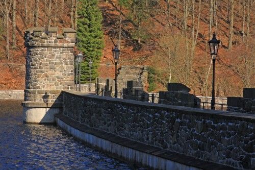
At first, we will be creeping among trees until we reach a very steep slope, which we must ride down very carefully /3/! Then we join a comfortable downhill road, which will take us slowly along the Kamenička river until we reach the dam with the same name - the Kamenička dam. On our way down we will see a lot of beautiful scenery. The impression created by the snow-covered rocks outlining the steep slopes of the valley together with silver oaks and the crystal-clear water of the Kamenička dam is simply unforgettable. The water dam Kamenička was built between 1899 - 1904. It has 31 m high wall and its entire bottom is paved. It is a technical monument which still serves its purpose today. When we pass the Kamenička dam, the road slope becomes steeper but it is not a slope that could not be handled by any average cross-country skier. Then our road will join another road which follows the Chomutovka River and which will take us to the Bezručovo údolí (Bezručovo Valley). Right here at this crossroad, you will find a small roof-covered resting place. Behind the resting place we will take a right turn and start climbing slightly up /1-2/ for the next 6 km and through one of the most beautiful valleys in Krušné mountains until we reach the crossroad sign Bezručovo valley. From here we will follow the red sign towards "Nový dům (New house) and hunting cottage", (5 km). (1.5 km in the opposite direction following the red tourist sign you will find Hora sv. Šebestiána (the Mountain of St.Sebastian). The first 800 m are rather steep /3/ and we will have to use herring-bone climbing technique to manage. Then our climb becomes less steeper /2/ and after several hundred meters we will reach the upper terrace again. Up here we continue on a flat plain and through slightly hilly terrain We will pass by a small picturesque pond and behind it, we take a right turn down . Now we take a slight 1.5 km long descent and immediately after that another 1.5 km long climb, which will take us to Nový rybník (New pond). Behind the pond we will take a left turn and follow the blue sign, which will take us for the next 4 km through Novodomský peat-bog. The National park Novodomské rašeliniště (peat-bog) is a strictly protected land because it represents one of the largest peat-bogs in Krušné mountains. Then we come to a road connecting the former village Pohraničí with Načetín. During the winter, this road is only plow-maintained and therefore, may also be used by cross-country skiers. We will take this road too and follow it to the right, towards Načetín. We can also use the road to go through Načetín all the way to Kalk. Or, we may choose to turn right after about 300 m onto a forest road with a gate arm, which is used by cross-country skiers very often and which runs almost in parallel with the main road. Plus we can be sure that our ski track is good and that we will not interfere with the traffic. After approximately 2.5 km of alternating uphill climbs and descents, we will come close to a yellow tourist sign connecting Kalk with St. Anna. We take this direction to go back to Kalk, but we will not turn towards "Jeskyňka" (Small cave) but keep straight ahead, go around the Bachňák pond and a rest place, and after a short ride we will reach the beginning of the village where we started. Total length 31 km. Other recommended starting points: the Mountain of St. Sebastian – follow the red sign for 2.5 km to "Bezručovo valley“, III. Mill House


