


Select from ...
-
 Explore
- Castles and ruins
- chateaus
- churches (religious monuments)
- museums and galleries
- vernacular architecture
- industrial
- lookout towers
- educational trails
- Zoo
-
 Relax and Sport
- spa and wellness
- theatres and cinemas
- water parks and swimming
- fun for children
- sport venues
- indoor and outdoor rock climbing walls
- Golf
- ski areas
-
 Services
- accommodation
- meals
- craft breweries
- wineries
- rentals
- transportation
Dolní Poohří
Krušné hory
České Švýcarsko
České středohoří
Transport method:


Search results:

Borečský Peak National Natural Landmark
The difference between the temperature of the air escaping from the peak and the surrounding air sometimes reaches 16°C. The area was declared a protected area in 1951 and it covers 18.7 hectares. Boreč massif is a morphologically perfect mound - a perfectly prepared laccolith created by sodalite trachyte, that is interwoven with a complex fissure labyrinth. In summer it acts as a thermal accumulator and in winter it is much warmer than the surrounding countryside. On the ...

Historical buildings of the Association for Chemical and Mining Production - Ústí nad Labem
The original building of Spolchemie Headquarters was built in the Neo-Gothic style by the architect Robert Langs in 1895. The most impressive part of the building is the main staircase hall with a large wall painting by Josef Reiner dating back to 1900. On the first floor there is a meeting room of the Board of Directors, boasting a preserved Neo-Gothic interior. The original administrative building of the Association stopped serving its purpose in 1931 and it was rebuilt into ...
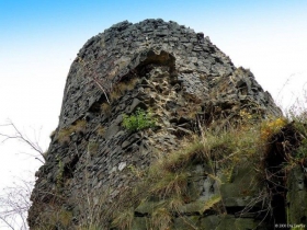
Ruins of Ostrý Castle - Františkov nad Ploučnicí
The ruins of Ostrý Castle have been declared a cultural heritage. The castle was founded in the middle of the 13th century and from ca 1515 it was deserted. Nowadays, we can see only remains of the castle walls, from the top you will have beautiful views across the countryside.There are information boards on the history of the castle placed along the ascents to the ruins. Go to the website ofFrantiškov nad Ploučnicí!
Kohout Observation Tower - Valkeřice
There is an observation tower at the top of Kohout Peak (589 metres above sea level.) The observation tower is a 12 m high building with one observation platform. You will have views towards the north and east, namely you will see Česká Lípa, the peaks of Ještěd, Valkeřice and Strážný. There is a blue marked trail leading to the observation tower and you can follow it from Benešov nad Ploučnicí, or approach it from the south or ...
Ejem's Chalet with Frotzl's Observation Tower - Dobroměřice
This tourist chalet and its observation tower were built in 1911 by the Louny branch of the Czech Tourists Club. The proposal to construct the chalet was made by the chair of the branch, Josef Ejem, and the chalet was later named after him. The observation tower was named after Frotzl.
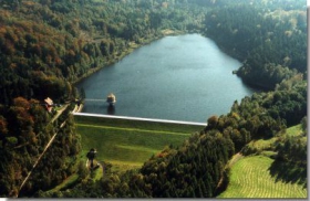
Chřibská Water Reservoir
The water reservoir was constructed in 1912-1926 as an antiflood measure, but later it started to be used also for recreational purposes. The water reservoir and its catchment area are situated in a woodland area. Winter is relatively long in this area and there is a lot of snow. The reservoir usually freezes for three months but the ice does not present any major problem. The reservoir is protected against floating solids by the basin made of broken stone, that is situated right ...
Dubí hora - Úštěk
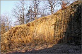
Dubí hora was made a Natural Monument in 1966; it has an area of 0.089 hectares, and is 360 m above sea level. Originally this was a stone quarry on the front of lava flow, with a column to loaf tephrite decay. Endangered plants can be found around Dubí hora - burnt orchid and rock cinquefoil. Dubí hora is also known as Konojedské bochníky (loaves) due to the shape of the rock. There is no colour-marked tourist track leading to the ...
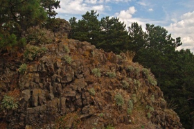
Kuzov Natural Landmark - Třebenice
The rugged rocky ridges of Kuzov protrude through the growth of the European Black Pine, which is not indigenous but is no longer spreading; the rocky area is a home to many plant species typical for rocky savannas. Protected species, such as the golden alyssum, small pasque flower, feather grass, St Bernard's lily and flora of Siberia can be found here. The fauna living in the actual reserve is not sufficiently known. We have several records of molluscs (an important species for ...
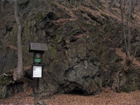
Vrása near Osek
The natural landmark, called Vrása, is situated ca 4 km from Osek on a wooded slope of the Krušné Mountains. The rock formation documents the Paleozoic processes taking place in the Krušné Mountains. Remains of silver ore mining can be seen in the surroundings. A blue marked tourist track coming from Osek will take you very near this natural landmark.
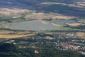
Újezd Water Reservoir (Kyjice)
In the 1970s and 1980s endless brown coal reserves were uncovered in Northern Bohemia, regardless of the negative impact on the environment. Many villages had to succumb to the coal. The construction of the reservoir started in 1978 and three years later it was completed, taking with it the last house in Kyjice in 1980. The bustle of the village life was replaced with the rustle of the reservoir water. The reservoir covers just under 153 hectares and the average depth is ca 10 to 11 ...
