


Select from ...
-
 Explore
- Castles and ruins
- chateaus
- churches (religious monuments)
- museums and galleries
- vernacular architecture
- industrial
- lookout towers
- educational trails
- Zoo
-
 Relax and Sport
- spa and wellness
- theatres and cinemas
- water parks and swimming
- fun for children
- sport venues
- indoor and outdoor rock climbing walls
- Golf
- ski areas
-
 Services
- accommodation
- meals
- craft breweries
- wineries
- rentals
- transportation
Dolní Poohří
Krušné hory
České Švýcarsko
České středohoří
Transport method:


Search results:
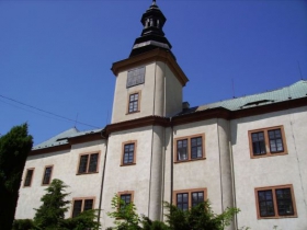
Mašťov Castle
The castle was built on the site of a former principality in the 13th century, but in 1421 it was burnt down by the crusaders. Nevertheless, the castle was repaired and it changed owners several times. In 1571 the castle was rebuilt into a Renaissance chateau during the reign of Jan Valdemar of Lobkowicz. During the reign of the Dukes of Goltz, who owned the estate from 1661 to 1791, the castle was given a Baroque look. In the 19th century it was used by the feudal authorities offices ...
Přísečnice Water Reservoir - Kryštofovy Hamry
The dam of the water reservoir is straight, rock-filled with medium earth padding. The reservoir is 469.7 m long in its crown, 10 m wide and the maximum height of the reservoir above the terrain is 47.2 m. The total flooded area amounts to 361.96 hectares with a total volume of 54.690 m3. In its deepest point the reservoir is 50 m deep. The main purpose of the reservoir is to accumulate water, providing a source of drinking water for the North Czech brown coal basin. It should also ...
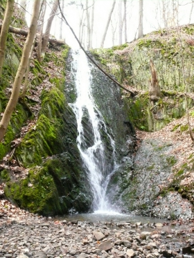
Bobří (Beaver's) Pass - Verneřice
The Bobří Stream has eroded a pass whose steep cliffs are now up to 30 m high. The stream passes through rapids, there are big boulders stuck in the river bed, and you will find a 6 m high waterfall on the tributary on the right hand side. A green marked tourist path goes through the pass, connecting Verneřice and Kravaře.
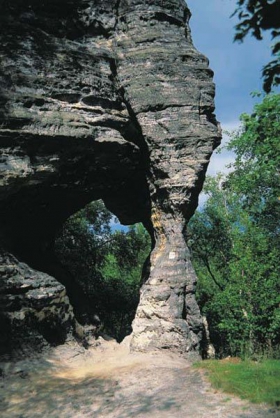
Rájec Rocks - Tisá
Rájec Rocks represent a uniform massif of hard sandstone with rocky towers, passages, windows and other segmentation. The rocky massif starts at the national border of the Czech Republic and Germany and goes southeast towards the village of Tisá where after ca 1.5 km it merges into the area of Tiské stěny. The area is divided into three parts: the area of Ptačí stěny (Birds' Walls) covers the rocks from the national border to the Rájec- ...
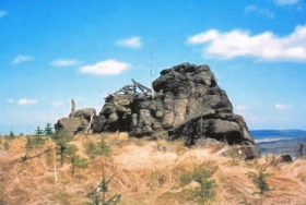
Medvědí skála (Bear's Rock) - Nová Ves v Horách
Medvědí skála (Bear's Rock) is the second largest mountain in the Most region and the highest peak of the Rudolická Highlands, with its 923.8 metres above sea level. The rock has a rounded top and on the flat crown of the mountain you will find rocks and big rounded boulders. The name of the mountain, Bear's Rock, refers to the sad occasion when the last bear of the Krušné Mountains was shot here in the 18th century. At the top there is a ...

Zlatník Hill - České Zlatníky
From Zlatník Hill (521 m above sea level) you see the České středohoří Mountains (Central Bohemian Uplands) and the wall of the Krušné Mountains as if on the palm of your hand. The wooded, and partly rocky clinkstone peak in the valley of the Bílina River is situated above the village of České Zlatníky. You can reach the top following an unkempt path and will be reawarded with some lovely views. The climb from the ...

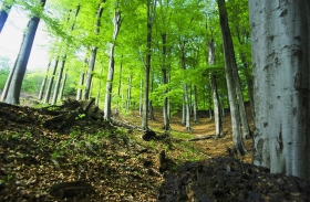
Březina near Milešovka Hill (nature reserve)
Very old beech trees (160-170 years) can be found in this nature reserve, along with a young peat bog with two floating islands - the only two in the Milešovské středohoří Mountains. Spatulate-leaved sundew was planted in the peat bog and it has soon dominated the peat bog area. Utricularia australis and Eriophorum angustifolium also flourish here. From the animal species, you can see the fire salamander, the European fire-bellied toad, the viper and the moor ...
Jezerka (National Nature Reserve)
Jezerka is a national nature reserve in the Krušné Mountains and it is one of the most valuable areas in the mountains. During the Quaternary period the rocky projections started weathering, creating peaks, frost-riven cliffs, rocking stones, rocks, fissure caves and a scree of boulders on the slopes of the hills. In 1969 this location was declared a national nature reserve, named Jezerka, and it covers 130 hectares. The forests are also protected by the nature ...
Rubín Hill - Podbořany (Dolánky)
When leaving Podbořany on the way to Kadaň you will see the landmark of the town - Rubín Hill (352 m). Since 2 September 1993 the hill with a flat crown has been protected as an important landmark feature. The hill was inhabited nearly four thousand years ago, more specifically from the Stone Age to the Iron Age. Its eastern and northern slopes are especially very tall and steep, creating the natural defence structure of the settlement. The southern side is also steep, ...

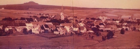
Dlouhá louka - Osek
Dlouhá Louka used to be an autonomous village but since 1961 it has become a part of the the town of Osek. The church and several typical Krušné hory houses from the 19th century represent the main landmarks of the village. Nowadays, the village is mostly used as a holiday destination. On the western part of the village, at the top of Vlčí Mountain (Wolf's Mountain) a telecommunication pole was erected; its gallery is accessible to the public and is a ...
